Beware the ‘North-East high-traffic superblock’: why Headington needs a traffic filter on Marston Ferry Road


What’s the Marston Ferry Road traffic filter?
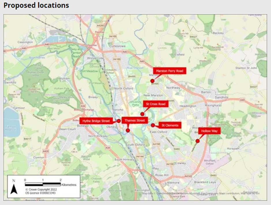
The traffic filter on Marston Ferry Road is one of six filters proposed in the Council’s Central Oxfordshire Travel Plan (“COTP”), and is one of the two filters proposed on the B4495.
The map below shows the proposed locations of the COTP traffic filters:
This plan produced by the Council shows the exact positioning of the proposed traffic filter on Marston Ferry Road:
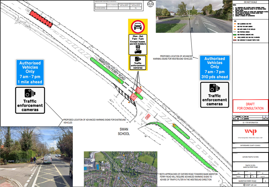
So it will be positioned just North of the Swan School entrance, which makes sense as people in the school’s catchment areas including Marston, Headington (North of London Road) and Barton Park access it from the South.
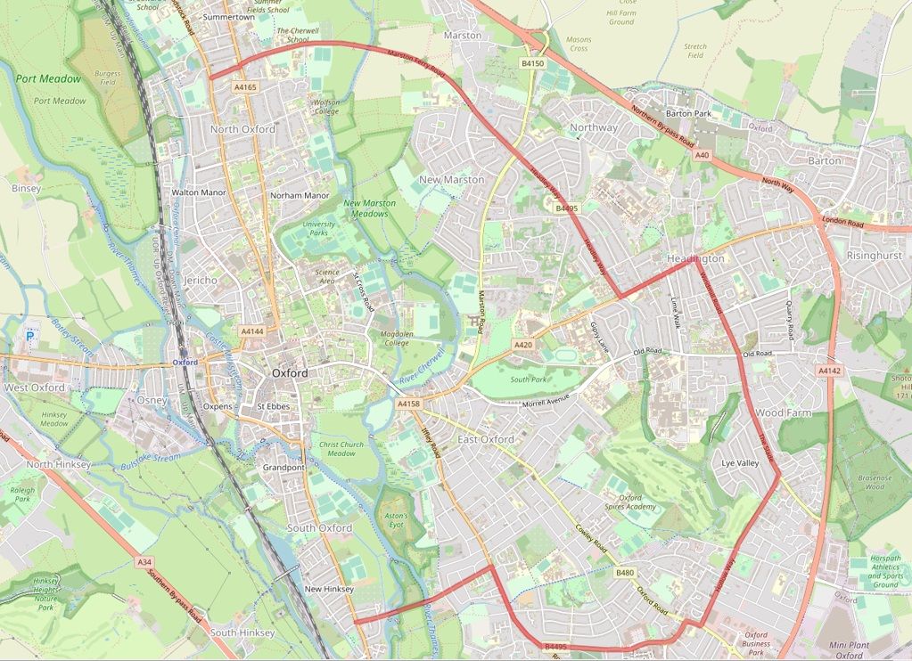
Marston Ferry Road forms part of the B4495, which is effectively an ‘inner ring road’ that runs through the Eastern side of Oxford from Summertown in the North to Abingdon Road in the South comprising Cherwell Drive – Headley Way – Windmill Road – The Slade – Hollow Way – Between Towns Road and Donnington Bridge Road, as shown in red on the map below:
The importance of the Marston Ferry Road traffic filter
This particular filter is vitally important for Headington for a number of reasons.
However, we are concerned that it is at risk of being dropped due to lack of support by local councillors and some residents.
In this post, we attempt to explain why we need the Marston Ferry Road traffic filter.
Reducing traffic volumes and congestion to make bus and active travel improvements
A key function of traffic filters is to reduce the volume of traffic. A filter on a particular road will reduce the volume of traffic on that road and on all the feeder roads surrounding it. So, a traffic filter on Marston Ferry Road will reduce traffic volumes not only along Marston Ferry Road but also on surrounding residential roads such as Cherwell Drive, Oxford Road, Headley Way and Banbury Road.
That traffic reduction will enable the following public benefits to be realised:
- Better bus services – with less congestion, existing bus services that use Marston Ferry Road and surrounding roads (such as the 700 Thornhill P&R to Kidlington and Oxford Parkway, H2 John Radcliffe to Witney and 14A John Radcliffe – Summertown – Oxford) can be improved in terms of journey times and reliability.
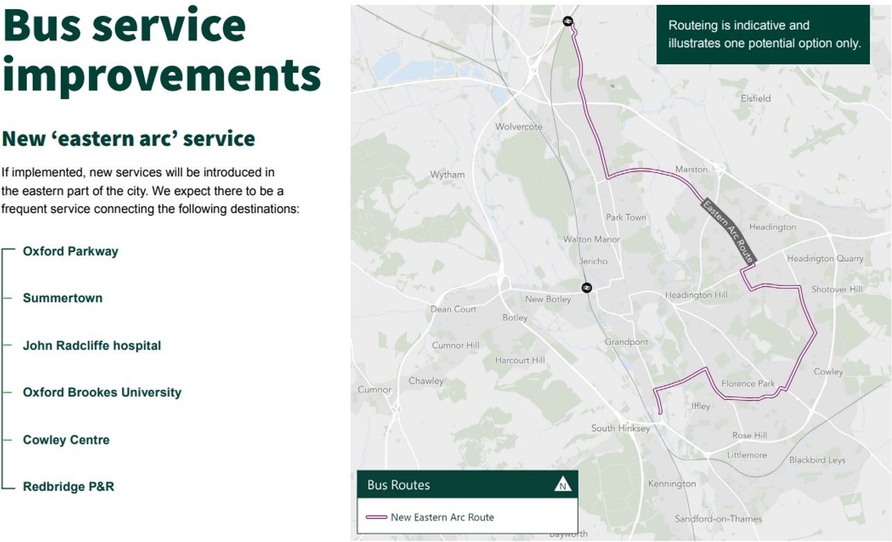
- New bus services – the reduction in congestion will also allow the new ‘Eastern Arc’ bus route proposed in the COTP (shown below) to be run, linking up the whole East side of Oxford from Oxford Parkway in the North to Redbridge Park & Ride in the South via Summertown, Marston, Headington, Wood Farm, Lye Valley, Horspath, Cowley, Iffley and Donnington, which will be a hugely useful bus route for many people, including Headington residents, and has the potential to replace many car journeys that currently take place between those destinations. The B4495 ‘inner ring road’ forms the basis for the new bus route, so it needs to be uncongested to allow for buses to run smoothly – which is why a further traffic filter is proposed for Hollow Way.
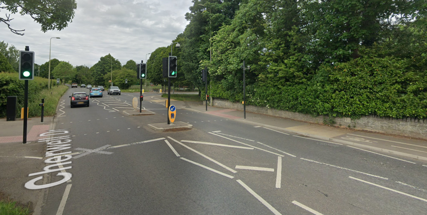
- Improved Banbury Road junction: reducing traffic volumes through this junction will make it possible to remove the left-turn traffic lane on the approach to Banbury Road and reduce the vast road area currently dedicated to cars to provide more space and priority crossings for cyclists and pavement users, making it safer and easier for people walking, wheeling and cycling to use.
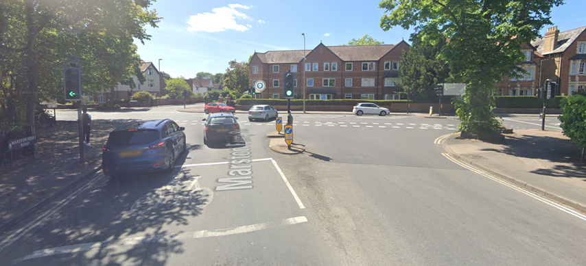
- Improved Cherwell Drive junction: reducing traffic volumes through this junction will make it possible to change the crossing (currently a pelican crossing with a long wait time for pedestrians and cyclists, a pole stuck in the middle of the cycle path and no alternative dropped kerb to get on the cycle path) to a zebra crossing (or at least a pelican crossing that gives an immediate green light for cyclists and pedestrians) with a narrower road, shorter crossing distance, no obstructing posts and a dropped kerb to enable people to easily access the cycle path.
Ensuring Headington’s roads only take the burden of traffic destined for Headington
The filter is also needed to ensure that Headington only has to take traffic destined for Headington, not also traffic destined for Summertown, Jericho, North Oxford, Cutteslowe, Kidlington and the City Centre via Banbury Road.
Even with the Marston Ferry Road traffic filter, Headington will still form part of a relatively high-traffic suburb stretching from Horspath Driftway in the South to Elsfield Road in the North.
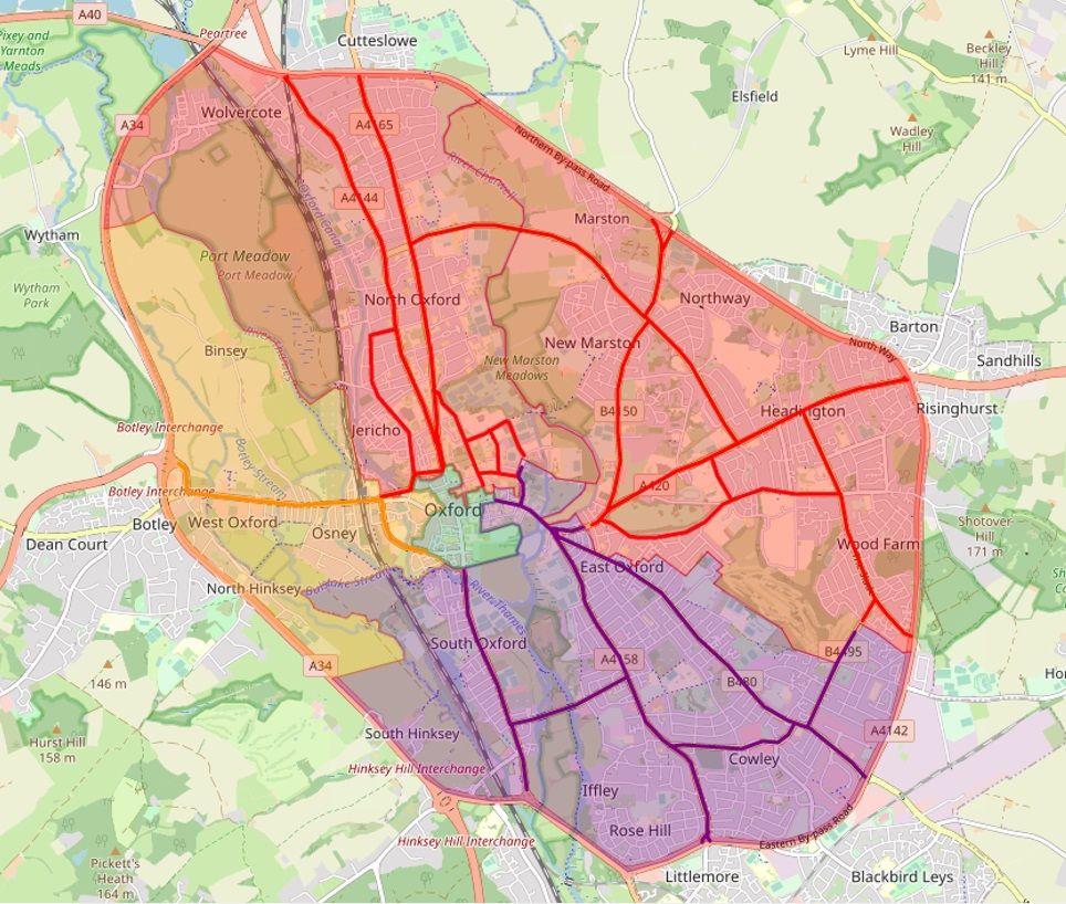
Without this filter, Headington will form part of a ‘North-East high-traffic superblock’ between Horspath Driftway and Wolvercote Roundabout.
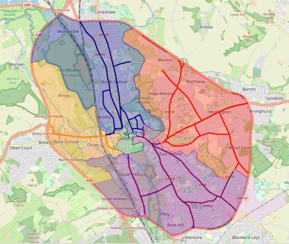
These two scenarios are compared in the maps below:
With the Marston Ferry Road filter:
Without the Marston Ferry Road traffic filter:
Fact-checking the arguments against a traffic filter on Marston Ferry Road
We’ve heard a few arguments against this filter, which we’ve addressed below:
“Marston Ferry Road has a fantastic cycle track so doesn’t need a traffic filter”
The existence of a good cycle track on Marston Ferry Road is not relevant to the benefits described above, which can only be achieved by reducing traffic through the use of a traffic filter.
If anything, the existence of a good cycle track there means there is less need and justification for cars to use that road, as people in Marston can get to Summertown safely and easily by bike, mobility scooter and other micro-mobility devices on Oxford’s best cycle track (and vice-versa).
“Marston Ferry Road is an arterial road so cars shouldn’t be prevented from using it”
Marston Ferry Road, forming part of the B4495 ‘inner ring road’ which goes between different sections of Oxford, is exactly the sort of road that needs to have motor traffic removed from it as part of an effective city-wide traffic management plan.
The aim of the COTP traffic filters is to significantly reduce motor traffic on the inner arterial routes and force it to go out to the actual ring road, leaving the inner-city roads clear for people who need to use a car for disability reasons, buses, emergency vehicles and other public service vehicles, and safe for people walking, wheeling and cycling.
By positioning traffic filters on the B4495 to remove congestion caused by private cars, the Council aims to make this inner ring road serve as an efficient arterial route for existing and new bus services, which will be of particular benefit to those who cannot afford a car or are unable to drive due to disability or age and therefore rely on buses to get around.
“Marston Ferry Road was purposely built as an arterial route for cars and should stay like that”
Whilst it’s true that Marston Ferry Road was built as an arterial road, this argument fails to acknowledge the mistakes of the past.
Marston Ferry Road was built in 1971. This was at a time when car ownership was tiny compared to today’s levels and the transport planners could not have predicted the millions of car journeys that the road would generate on it and all the surrounding residential roads in Marston, Headington and Summertown.
It was built at a time of peak car-centric planning aimed at providing for mass private car use, which we have come to know was a huge mistake for environmental, health and safety reasons.
We are now all paying the price for this car-centric planning in Oxford with congested roads, unreliable buses, unsafe and unpleasant cycling and walking conditions and illegal levels of health-damaging air pollution.
If we could go back in time to 1971 knowing what we know now, we would build Marston Ferry Road as a public transport and active travel superhighway with safe, prioritised cycling and walking crossings at either end and various positions along it.
But we can’t go back in time, so we need to try to achieve that retrospectively now, and putting a traffic filter there is the first step to enable that.
Making the COTP traffic filters work for Headington
Headington needs the Marston Ferry Road traffic filter for many reasons, which we hope we have been able to explain in this post. Losing it from the scheme would be disastrous for active travel and bus use in Headington. Please respond to the Council’s consultation on traffic filters and support this key traffic filter.
Related articles